Résultats de la recherche : "DDE 22 IGN" 21 résultats
Notice d'illustration

IVR53_20042204283NUCB
|
Présentation de la commune de Ploumilliau
Légendes carte IPLI de Lannion : Espaces agricoles et espaces naturels
Notice d'illustration

IVR53_20042204284NUCB
|
Présentation de la commune de Ploumilliau
Légendes carte IPLI de Lannion : Habitat et Espaces urbanisés
Notice d'illustration
IVR53_20042204285NUCB
|
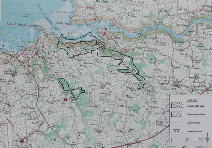
Présentation de la commune de Ploumilliau
Cartographie des espaces littoraux remarquables de Ploumilliau
Notice d'illustration
IVR53_20042204312NUCB
|
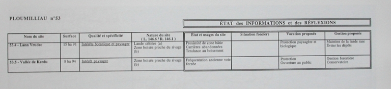
Présentation de la commune de Ploumilliau
Cartographie des espaces littoraux remarquables de Ploumilliau : légendes Protection et Gestion
Notice d'illustration
IVR53_20042204286NUCB
|
Présentation de la commune de Ploumilliau
Cartographie des espaces littoraux remarquables de Ploumilliau : légendes Protection et Gestion
Notice d'illustration
IVR53_20042204288NUCB
|
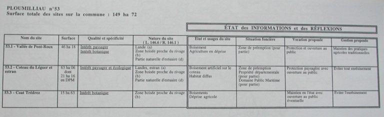
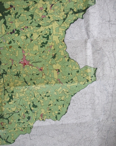
Présentation de la commune de Ploumilliau
Cartographie des espaces littoraux remarquables de Ploumilliau
Notice d'illustration
IVR53_20042204289NUCB
|
Présentation de la commune de Ploumilliau
Carte IPLI de Lannion, Ploumilliau : Inventaire Permanent du Littoral, Usage du sol, 1977, 1982
Notice d'illustration
IVR53_20042204282NUCB
|
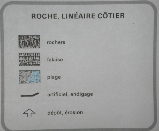
Présentation de la commune de Ploumilliau
Légendes carte IPLI de Lannion : Roches et Linéaire côtier
Notice d'illustration

IVR53_20042204281NUCB
|
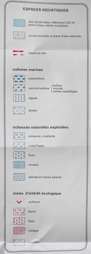
Présentation de la commune de Ploumilliau
Légendes carte IPLI de Lannion : Espaces aquatiques
Notice d'illustration
IVR53_20042205032NUCB
|
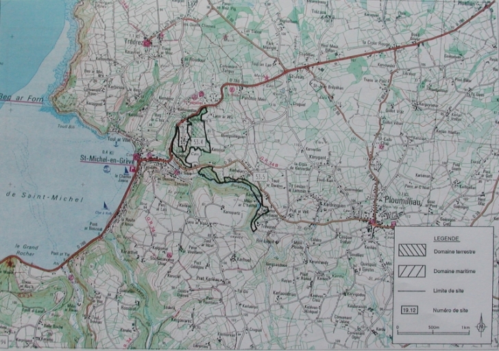
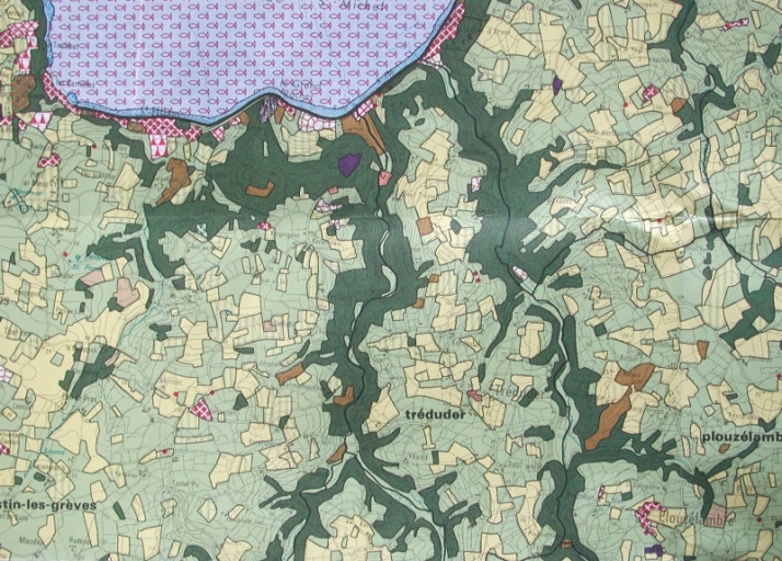
Présentation de la commune de Tréduder
Carte IPLI de Lannion : Tréduder
Notice d'illustration
IVR53_20042205022NUCB
|
Présentation de la commune de Tréduder
Légendes carte IPLI : Espaces aquatiques
Notice d'illustration
IVR53_20042205031NUCB
|
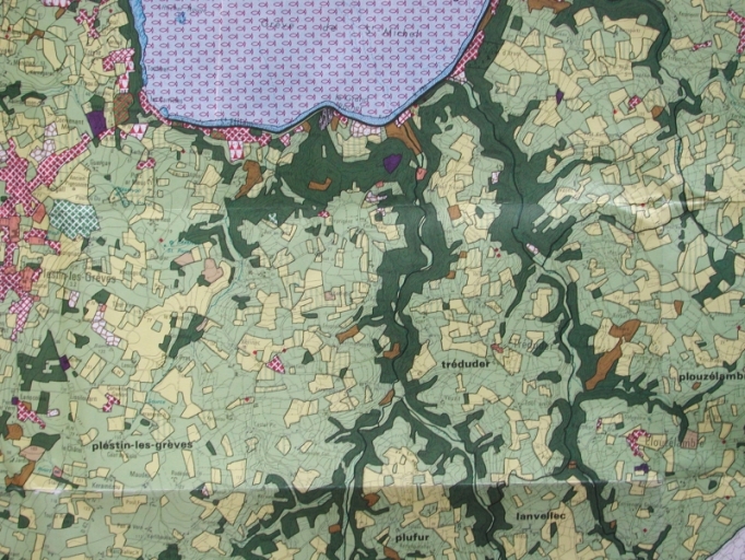
Présentation de la commune de Tréduder
Carte IPLI de Lannion : Tréduder et son environnement
Notice d'illustration

IVR53_20042205021NUCB
|
Présentation de la commune de Tréduder
Légendes carte IPLI : Espaces agricoles et Espaces naturels
Notice d'illustration
IVR53_20042205023NUCB
|
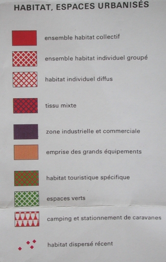
Présentation de la commune de Tréduder
Légendes carte IPLI : Habitat et Espaces urbanisés
Notice d'illustration

IVR53_20042205024NUCB
|
Présentation de la commune de Tréduder
Légendes carte IPLI : Roches et linéaire côtier
Notice d'illustration

IVR53_20042203639NUCB
|
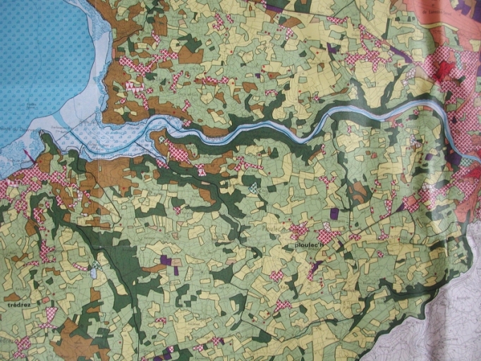
Présentation de la commune de Ploulec'h
Légendes carte IPLI de Lannion : habitat et espaces urbanisés
Notice d'illustration

IVR53_20042203638NUCB
|
Présentation de la commune de Ploulec'h
Légendes carte IPLI de Lannion : espaces agricoles et espaces naturels
Notice d'illustration

IVR53_20042203637NUCB
|
Présentation de la commune de Ploulec'h
Légendes carte IPLI de Lannion : rochers, linéaire côtier
Notice d'illustration

IVR53_20042203635NUCB
|
Présentation de la commune de Ploulec'h
Légendes carte IPLI : Espaces aquatiques
Notice d'illustration
IVR53_20042203613NUCB
|
Présentation de la commune de Ploulec'h
Extrait carte IPLI Lannion : Inventaire Permanent du Littoral, 1977-1982